

Polygons
68 maps by 66 mapmakers for day 3 of the #30DayMapChallenge 2026 (3 November 2026), theme “Polygons”, collected from public posts on Bluesky and Mastodon.
Maps for day 3: Polygons
1/3
Day 3: Polygons. On Oct 27, 21 of 75 western basins had land in extreme or exceptional drought. Severe drought or worse covered 47% of their land on Aug 4 and 23% on Oct 27. Utah's Jordan basin was s…
Brian Busch, GISP
@buschbrian.bsky.social
#30DayMapChallenge Day 3: Polygons Maryland's 1632 royal charter describes the colony in "metes and bounds" text. This map draws it and annotates the key phrases. (Why it doesn't match today's border…
Chris Whong
@chriswhong.bsky.social

A bit late for day 3 of #30DayMapChallenge (Polygons), but here's my entry: a general sorter for US state shapes. Pick a statistic (population, land area, density, ...) and the fifty states line up b…
Julien Colot
@jcolot.bsky.social
#30DayMapChallenge Day 03 · Polygons Sticking with NYC 311 data for one more map. Each Manhattan neighborhood’s top 311 complaint in 2025. Heat and hot water wins in nine, all uptown. The surprise wa…
Melissa Hegeman
@mel-likes-maps.bsky.social
Running a bit late with the map for the #30DayMapChallenge day 3: Polygons. This map shows where coffee is grown across Mexico, Central America, and the Caribbean. Data: SPAM 2020, v2.2, by the Inter…
Cristina Poiata
@this-is-cris.bsky.social
#30DayMapChallenge, day 3 - polygons Another take on Land does not vote, people do: On the right, the difference of votes for either Democrats or Republicans (the winning margin) in the 2024 presiden…
Michal Škop
@michalskop.bsky.social
Our contribution to Day 3—polygons—of the #30DayMapChallenge is from CGA visiting post-doc @martinapardy.bsky.social. Over her past month here, Martina says she couldn't help but notice how green Cam…
Center for Geographic Analysis @ Harvard
@cga-harvard.bsky.social
#30DayMapChallenge Day 3 - Polygons Round Valley Reservoir, NJ, USA Today’s map features contour polygons made from a digital elevation model, with a continuous color ramp linked to the data’s elevat…
Tiffany Chau
@tchaulla.bsky.social
Do you know how many time zones there are in the Soviet Union? youtu.be/QDmWYVdN8ug?... #30DayMapChallenge Day 3: Polygons #Negativland
Robert Simmon
@rsimmon.bsky.social
#30DayMapChallenge Youth edition Day: 3 - Polygons & 4 - Clusters Map: Schiedam, NL Challenge: Draw the plants of your ideal allotment garden.
clementinecttn.bsky.social
@clementinecttn.bsky.social
Day 308 of #365DaysOfMaps. November 4th is National Candy Day. What's your favourite NERD Cluster flavour? #30DayMapChallenge day 3 tie-in: clusters The United States of Gummy Clusters (308/365) mapd…
Kenneth Field
@kennethfield.bsky.social
30 Day Map Challenge 2026 · Day 3 · Polygons: Block to block to Big Data My 50-minute walk from Kitsilano to the Big Data & Analytics West Summit in Vancouver. The 31 city blocks I passed are in full…
Andrew Tyrrell
@southarrowmaps.co.nz
#30DayMapChallenge Day 3: Polygons. I look at parcels in the City of Madison and try to identify weirdly shaped ones. https://haraldkliems.netlify.app/posts/2026-11-03-30daymapchallenge-polygons/ #RS…
Harald Kliems
@haraldkliems.fosstodon.org.ap.brid.gy
#30DayMapChallenge Day 3: POLYGONS @SCALE - Cartographic representations of Lisbon in 1833 (originally in 1:52000) and 1835 (originally in 1:10500). The 1833 version is simplifyed with large polygons…
jpamado.bsky.social
@jpamado.bsky.social
Day 3: Polygons. Terceira, Azores. Museu de Angra do Heroísmo and Nossa Senhora da Guia: 27 Fotoshi photos, two mapped buildings. Photos: strabo, CC BY 4.0. Footprints: © OpenStreetMap contributors.…
Fotoshi
@fotoshi.bsky.social
🗺️ #30DayMapChallenge Day 3 - Polygons 🗳️ #Midterm2026
Jean-Marc Viglino
@jmviglino.bsky.social
Day 3, Polygons: Vienna is characterized by neighborhoods with a high variety of tenure types side-by-side. The spatial mix of housing types, a high share of social housing, and capped rents in histo…
Institut für Stadt- und Regionalforschung
@isroeaw.bsky.social
Quand géométrie et géographie se mêlent ! 🗺️🩵📐 #30daymapchallenge – J3 #polygons 📊 BD ALTI® · BD TOPO® · BD CARTO® ✍️ Benjamin Saglio Inspirée des "Villes rangées" d'Armelle Caron Retrouvez toute…
IGN
@ignfrance.bsky.social
#30DayMapChallenge Day 3 - Polygons This one maps the areas (that's the polygons!) of the 10 largest ski resorts in Austria and shows it side by side with a bar chart ranked by kilometers of downhill…
Walter M. Rafelsberger
@walterra.dev
1/3
#30DayMapChallenge Day 3 - Polygons Code: observablehq.com/@deepalikank... #DataViz #DataVisualization #Maps #Art #History #Museums
🪔Deepali Kank🪔
@deepalikank.in
Day 3 · Polygons. Barcelona's Eixample with every building drawn as a black polygon: Cerdà's grid of chamfered blocks, cut by Avinguda Diagonal. Data: © OpenStreetMap, Overture Maps. Made with Printe…
relytworks.bsky.social
@relytworks.bsky.social

#30DayMapChallenge Day 3: Polygons In 1850, each of the 40 largest Swiss glaciers was a single piece of ice. By 2023, they had shrunk and broken into over 200 pieces. visquill.com/gallery/swiss-glaci…
Benjamin Niedermann
@visben.bsky.social
Day 3 of the #30DayMapChallenge is polygons and I just couldn't bring myself to do anything related to elections (triggered). Instead, population loss and so much of it, geographically speaking...
Rachel Franklin 🦚
@rsfrankl.bsky.social
Day 3: Polygons #30DayMapChallenge In Rio de Janeiro's summer, Pix goes to the beach too. Arraial do Cabo (pop. 31k) receives 172,000 more Pix transactions a month than usual, 24% more. Inland, almos…
Franco Guiragossian
@dataviz.ar

🟣 Day 3/30: Polygons | The Radius of Innovation What if your map could scan an entire area instead of just one point? 🔍 Today I'm exploring rectangular hitTest(), new in ArcGIS JS SDK 5.1 (beta), w…
Courtney Yatteau
@cyatteau.bsky.social

#30DayMapChallenge Day03: Polygons The shift from combustion-engine cars to electric vehicles (EVs) is an important step towards tackling climate change. Germany has nearly 50 million registered pass…

NordAufNordost
@[email protected]
#30DayMapChallenge Day 3 - Polygons I've done Oregon's wildernesses before, and I'll do them again because I'm enamored with them. Here they are in descending order of area. The Clackamas throws a cu…
Chaney Swiney
@chaneyswiney.com

#30DayMapChallenge Day 3 - Polygons Taking shots at my own employer today (actually just one specific department). We (GIS) have offered our Clerk reports, analysis, dashboards, you name it. We've sa…

Josh Carlson
@[email protected]
#30DayMapChallenge - Day 3 Polygons. Man I went a million different ways with this. But here's where I ended up. Newcastle and Gateshead buildings only.

Tom watson
@tomcw.xyz

Day 3 of the #30DayMapChallenge - polygons. Potential superblocks of Vienna. Via #BikeNetKit (to launch soon..), with @moritz .

Michael Szell
@[email protected]
Day 3 of #30DayMapChallenge, Polygons. How far you get from Uppsala Central Station in 20 minutes at 08:00. By bike it's about 24 km², four times the area you reach by bus and on foot. Code: https://…
Georgios Karamanis
@karaman.is
 1/2
Day 3 of the 30 day map challenge - polygons. I cunningly saved myself lots of time today by remaking a map I made a few years ago: the fraction of French principal residences with zero cars. Between…

Oliver Blanthorn
@[email protected]
Half of Europe's tourist nights happen in just 102 of its 1,247 regions #30DayMapChallenge Day 3: Polygons
Josep Ferrer
@rfeers.bsky.social
#30DayMapChallenge #Tanzania Day 03: Polygons-Bonus 🇹🇿 Tanzania’s changing regional map: eight snapshots from colonial provinces to the present mainland system (1948 to 2026) Historical outlines ar…

Hemed
@725hemeed.bsky.social
1/2
⚽ What if distance chose your football club🇹🇿? Day 03: Polygons 16 selected clubs divide Tanzania into Voronoi territories, with a closer look at Dar’s clubs. Nearest mapped location—not fan suppor…

Hemed
@725hemeed.bsky.social

#30DayMapChallenge Day 3: Polygons After inflation, average house prices in the year to August were lower than ten years earlier in 169 of 317 councils in England and Wales. In August 2022 it was 41.…
Kerbsight
@kerbsight.co.uk
1/4
#30DayMapChallenge Day 3: Polygons I mapped every building in Minneapolis and St. Paul by the year it was built. You can clearly see the built environment that grew up around streetcars, then persona…
Jake Steinberg
@jakesteinberg.com
Day 3, Polygons: each shape is everything within 800 m of a metro or rail station in seven Indian cities. Purple dots are where people live. In every city, most residents live outside them. Made by a…
Oatflake Lab
@oatflakelab.bsky.social
Day 3 of #30DayMapChallenge · Polygons Every fire around Groveland There's more behind it on the page. #wildfire #SierraNevada brooksgroves.com/30DayMapChallenge/2026/share/day-03.html
Brooks Groves
@bdgroves.bsky.social
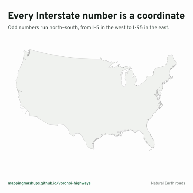 1/3
#30DayMapChallenge with @stamen, Day 3: "Polygons". The US Interstate system is numbered like a grid. Two gradients: odd routes run north–south, increasing west to east; even routes run east–west, in…

Alan McConchie
@[email protected]
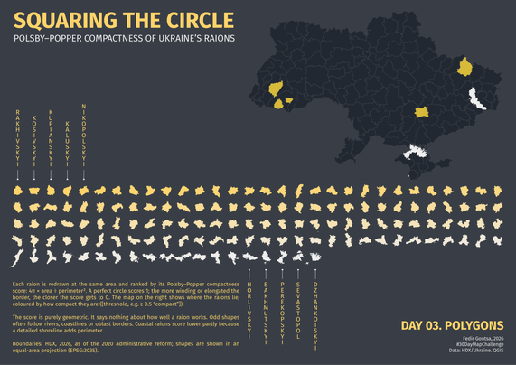
#30DayMapChallenge Day 3: Polygons Squaring the Circle How round is a raion? I redrew every raion of Ukraine at the same area and ranked them by Polsby–Popper compactness (1 = perfect circle). Spoile…

Gontsa
@[email protected]
On Day 3, #30DayMapChallenge : it's 'polygons'. For mapmakers, a polygon is a closed shape – so that could be a lake, or even a country. In 1945 the Allies drew four polygons over Berlin: this US Sta…
Merryn
@merrynwalters.uk
#30DayMapChallenge Day 3 — Polygons 🔥 Explore decades of wildfire history with Wildfire History Explorer, an interactive map with Mapbox GL JS using real USGS wildfire perimeter data. The project sh…
Mapbox
@mapbox.com
#30daymapchallenge Day 3: Polygons. Messed around with some intersections and coloring here #rstats #ggplot
dr-iggs.bsky.social
@dr-iggs.bsky.social

#30DayMapChallenge Day 3: Polygons 🟧 Oregon requires every city to draw an urban growth boundary. Portland’s has grown only about 14% since 1979, while the cities inside it filled in. Built with Map…
Brad Simantel
@simantel.org
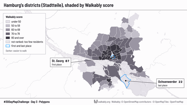
Day 3, Polygons: Hamburg's districts by walking score. The score measures the walk to eight daily needs and how pleasant the street is. St. Georg is in first place, 87. Ochsenwerder is in last place,…

Walkably
@[email protected]
#30DayMapChallenge #GISChat Day 3: Polygons - Park and Open Space Polygons in Aurora Colorado. Restricting myself to just the city of Aurora, has been fascinating. It has helped me learn about the ci…
Rachel
@rsteve388.bsky.social
Day 3 - Polygons #30DayMapChallenge Condo, rental and heritage buildings.
Halifax Shipping News
@hfxshippingnews.bsky.social


Showing 48 of 48 maps